
How to find us
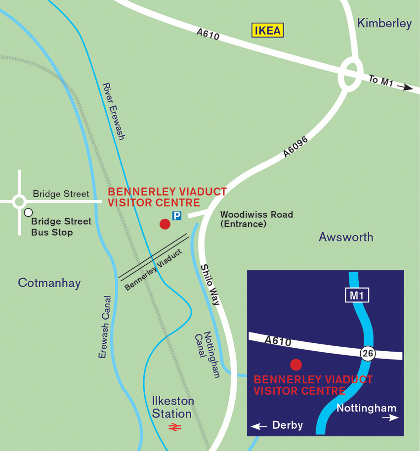
Bennerley Viaduct is between Cotmanhay and Awsworth, at Ordnance Survey grid reference SK 473 438, and the Visitor Centre is at What3words:///forced.props.cars.
Alternatively use the Google Maps pin https://maps.app.goo.gl/XaBUkx9tDeZpssnM7
The top of the viaduct is accessible by foot, cycle, wheelchair, mobility scooter or with a buggy from both the Erewash/Derbyshire and Broxtowe/Nottinghamshire sides.
There is a car park at the Visitor Centre, see below for more details; there are also many footpaths and cycle paths in the area, one of which goes across the viaduct. It can also be reached by public transport.
Coming to Bennerley Viaduct by public transport
By bus: the viaduct is served by buses from Trentbarton – the Ilkeston Flyer (from Derby) or Two (from Nottingham) to Bridge Street, Cotmanhay. what3words: ///ground.others.extend
By train: Ilkeston railway station, served by EMR trains is just one mile from the viaduct. The EMR regional service between Liverpool and Norwich stops at Ilkeston.
Coming on foot or two wheels
Find us on the Erewash Valley Trail either by foot or on your bike.
Coming by car
Bennerley Viaduct Visitor Centre car park is just three miles from junction 26 of the M1. There are two accessible parking bays as well as general visitor car parking.
What3words: ///forced.props.cars
Parking charges apply. You can pay using the RingGo app or by debit or credit card through the automated telephone service on 0203 046 0010.
The car park is managed on our behalf by an independent parking company and uses Automatic Number Plate Recognition (ANPR) cameras. All income from parking supports the charitable aims of Friends of Bennerley Viaduct.
Address: Shilo Way, Awsworth, Notts, NG16 2BF.